MAPS
This printable outline map of Africa is a great printable resource to build students geographical skills. This is an…
This printable outline of New Zealand and Australia is a great printable resource to build students geographical skills.…
Study geography with a printable outline map that depicts Canada.
This printable outline of West Indies is a great printable resource to build students geographical skills. This is an…
This printable outline of Mediterranean Sea Region is a great printable resource to build students geographical skills.…
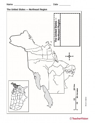
Use this resource to help students study the northeast region of the United States with this printable outline map. This…
WORKSHEETS
Handout a printable activity that asks students to name specific U.S. states.
ACTIVITIES
This printable game has students use Geography Flash Cards to test their knowledge of geographical terms, the world, and…
Use this printable geography quiz to assess students' knowledge of the names of the states of the United States by…
Use this printable geography quiz to assess students' knowledge of the names of the states of the Northeastern region of…
Handout a printable activity that asks students to color land and water on a world map and helps them distinguish…
Handout a printable activity that asks students to identify a few U.S. states.
Handout a printable activity that asks students to search for the countries of North America.
Handout a printable activity that asks students to search for the landforms of North America.
Handout a printable activity that asks students to search for a number of U.S. states.
Use a printable outline map that depicts the state of Maine.
Use a printable outline map that depicts the state of Maryland and the District of Columbia.
Use a printable outline map that depicts the state of New Hampshire.
Use a printable outline map that depicts the state of New Jersey.
Use a printable outline map that depicts the state of Pennsylvania.
Use a printable outline map that depicts the state of Rhode Island.
Use a printable outline map that depicts the state of Vermont.
Use this printable colorful map with your students to provide physical view of the world. After learning about this key…
Use a printable map to provide a political view of the United States. This social studies reference shows major U.S.…