MAPS
In this social studies printable, students will answer questions about topographic maps and practice map reading.
Review map symbols with this social studies printable. Students will use an atlas or other reference materials to…
Use this printable to review the key differences between Great Britain, the United Kingdom, and England—names that are…
Teach students about the origins and history of the Mason-Dixon line through the nonfiction text Boundaries. The…
Students learn about characteristics of U.S. regions by taking this printable geography quiz.
See how much your pupils know about ancient and recent history with this printable geography quiz.
Pupils learn about islands of the world by taking this printable geography quiz.
Quiz your pupils about the world's newest countries with this printable geography quiz.
Challenge your pupils' knowledge about the rivers and lakes of the world with this printable geography quiz.
EDITOR'S COLLECTIONS
Build students' geography skills with the maps and activities in this printable book. A range of maps covers both the…
Develop Earth science and geography skills with this printable. Students will use the descriptions to classify each…
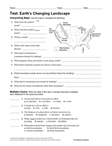
Multiple-choice and written-response questions in this Earth science exam are used to test students' knowledge and…
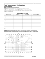
Using reference materials, students will research the location of ten earthquakes and complete a chart with the latitude…
Learn about the Geography Hall of Fame with information on the world's largest continent, longest lagoon, and more!
The following table lists the approximate land area, highest elevation, and lowest elevation of the world's continents,…
Learn about the differences between climate maps, topographic maps, and others types of maps.
A list of Christopher Columbus's voyages and the places he landed on each of them.
A chart listing interesting facts about each state.
A chart listing U.S. state capitals and the largest city in each state.
A chart listing the U.S. states by order of entry into the Union, year settled, and number of U.S. Representatives.
A chart listing U.S. National Parks.
A chart listing U.S. National Scenic Trails.
A chart listing the origin of U.S. state names.
A chart listing the extreme geographical points of the United States.