Add to Folder
creative writing
children's book
activities
classroom tools
language arts and writing
vocabulary
Create new folderCREATE NEW FOLDER
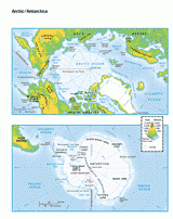
This printable colored map of the Arctic and Antartica is a great printable resource to build students geographical skills. This is an excellent way to challenge your students to color label all key aspects of these countries. This is a great resource to use in your classroom to teach your students about the development of the section, its' various cities, geologic formations, rivers and more.

Scott Foresman, an imprint of Pearson

Provided by Scott Foresman, an imprint of Pearson, the world's leading elementary educational publisher. Its line of educational resources supports teachers and helps schools and districts meet demands for adequate yearly progress and reporting.
Featured Middle School Resources

History of Earth Day Reading Passage and Quiz

ACTIVITIES

Earth Day Activities: History of Earth Day Reading Passage and Quiz

Help your students work on their reading comprehension skills while learning all about Earth Day with this reading compr...

Add to Folder
creative writing
children's book
activities
classroom tools
language arts and writing
vocabulary
Create new folderCREATE NEW FOLDER
Test Prep Strategies and Practice for Students

ACTIVITIES

Test Prep Strategies, Tools, and Practice Questions

Help set your students up for academic success with this packet of test-taking tips, test preparation strategies, and pr...

Add to Folder
creative writing
children's book
activities
classroom tools
language arts and writing
vocabulary
Create new folderCREATE NEW FOLDER
Elements of Poetry Workbook

WORKBOOKS

Elements of Poetry Workbook

Use this poetry toolbox workbook to support your students to learn different poetic terms and devices, and then practice...

Add to Folder
creative writing
children's book
activities
classroom tools
language arts and writing
vocabulary
Create new folderCREATE NEW FOLDER

Related Resources

MAPS

Political Map of North America

Use this printable map with your students to provide a political and physical view of North America.

Add to Folder
creative writing
children's book
activities
classroom tools
language arts and writing
vocabulary
Create new folderCREATE NEW FOLDER

MAPS

Map of Maryland & DC

Use a printable outline map that depicts the state of Maryland and the District of Columbia.

Add to Folder
creative writing
children's book
activities
classroom tools
language arts and writing
vocabulary
Create new folderCREATE NEW FOLDER

MAPS

Types of Maps

There are several types of maps. Each show different information.

Add to Folder
creative writing
children's book
activities
classroom tools
language arts and writing
vocabulary
Create new folderCREATE NEW FOLDER

MAPS

Political Map of the World

Use this printable map with your students to provide a political and physical view of the world.

Add to Folder
creative writing
children's book
activities
classroom tools
language arts and writing
vocabulary
Create new folderCREATE NEW FOLDER

MAPS

Map of Idaho

Use a printable outline map that depicts the state of Idaho.

Add to Folder
creative writing
children's book
activities
classroom tools
language arts and writing
vocabulary
Create new folderCREATE NEW FOLDER

MAPS

Map of Illinois

Use a printable outline map that depicts the state of Illinois.

Add to Folder
creative writing
children's book
activities
classroom tools
language arts and writing
vocabulary
Create new folderCREATE NEW FOLDER
loading gif